Here’s a revised version of your text, making it more dynamic, understandable, and professional:
—
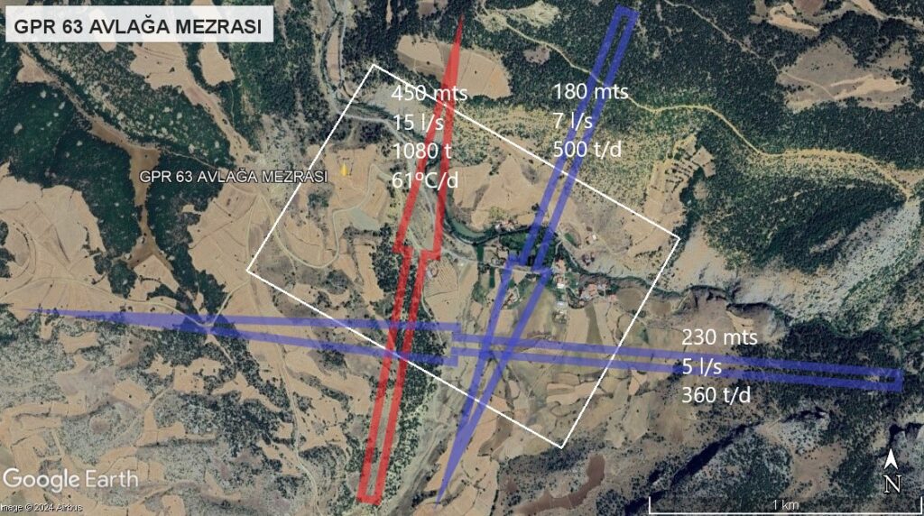
In the ongoing quest for sustainable solutions to ensure long-term water supply, the integration of satellite technology and artificial intelligence has emerged as a powerful tool for efficiently locating and harnessing underground water veins in a safe and environmentally friendly manner.
Traditionally, identifying groundwater sources has involved extensive geological surveys and costly drilling operations. However, with recent technological advancements, we can now leverage high-resolution satellite imagery combined with artificial intelligence algorithms to accurately and economically identify and map potential groundwater locations.
One of the primary advantages of this innovative approach is the ability to analyze large expanses of land remotely. Satellites capture detailed images of the Earth’s surface, and through the application of artificial intelligence, we can process this data to uncover patterns and features that may indicate the presence of underground water veins. This significantly reduces the time and costs associated with conventional exploration methods.
Moreover, the combination of satellite technology and artificial intelligence facilitates continuous, long-term monitoring of groundwater sources. Satellites can regularly observe identified areas, collecting updated data on water availability and quality. This capability enhances sustainable water resource management by preventing aquifer over-exploitation and protecting against contamination.
Another key benefit is the reduction of environmental impact. By minimizing unnecessary drilling, we lessen the risk of damaging underground ecosystems and prevent cross-contamination of aquifers. Additionally, optimizing the location of groundwater veins reduces the need for excessive infrastructure, thereby minimizing disturbances to the natural environment.
In summary, the fusion of satellite technology and artificial intelligence has proven highly effective in the remote identification of groundwater veins. Its benefits include enhanced efficiency in locating water resources, cost savings, long-term sustainability, aquifer protection, and the preservation of clean water sources. This innovative methodology is poised to play a crucial role in securing sustainable water supplies, helping to tackle the water challenges of the future.
To learn more about these groundbreaking technologies and their applications, subscribe to our YouTube channel, AQUAFUTURE, for insightful videos and updates!